


Surveillance City Exposed
An exclusive Sentinel report on Huntington Beach license plate camera locations


The Huntington Beach city council’s recent unanimous adoption of Resolution No. 2025-01 “declaring the City to be a non-sanctuary city for illegal immigrants for the prevention of crime” has prompted me to pull the curtain back on my work-in-progress investigation into the city’s use of Automated License Plate Reader (ALPR) cameras.
The resolution commits the police to using “every means and resource necessary” to aid federal law enforcement agents in the deportation of hard-working immigrants who only seek to pursue the American Dream of opportunity. Presumably this includes use of the ALPR network, a surveillance system hiding in plain sight that has been incrementally built over the past decade or so with minimal public scrutiny.
Online information about the ALPR network is scarce. In 2019, the state auditor surveyed cities about their use of ALPRs, and the city provided some basic information back when the network was still small. In 2022, there was a Spectrum News 1 article that was a fairly good summary. But the most detailed data to date was obtained by the Electronic Frontier Foundation (EFF) in a 2023 response to a California Public Records Act (CPRA) request sent to police departments throughout the state. That CPRA response is worth reading, because it reveals the many millions of yearly license plate detections in Huntington Beach and how they are widely shared. I find it very concerning.
But nobody has reported on specific ALPR locations until this post.
To date, I have mapped 23 locations being monitored by ALPRs, of which 21 are city-operated, and 2 are HOA-operated. Because ALPR data is usually shared, you should assume that both local police and federal law enforcement have access to non-city ALPR data. You can access this interactive map to see every monitored location in Huntington Beach and which direction the cameras are aimed. Read on to learn more about the map.
Few residents are aware of the current scope and expansion plans of the ALPR network. I aim to change that to allow residents concerned about their privacy to take action to protect it.
A Seed is Planted
Last fall, my Tesla’s FSD navigation became fond of taking eastbound Warner Ave to northbound Beach Blvd for my bi-weekly early morning grocery shopping at the Whole Foods at Bella Terra. This route passes along the northern boundary of the city’s Oak View neighborhood which is home to thousands of immigrants, many of them undocumented.
During morning rush, the traffic can move slowly in this direction, and with FSD safely driving the car, I was able to devote more mindshare to roadside scenery. Eventually I noticed solar panels and a camera attached to the street lamp on the southeast corner of Oak Ln at Warner Ave. I had been driving by there for YEARS and never noticed that camera before.

My mind flashed back to this 2017 Facebook post in which I recalled attending a city council study session a few years prior at which plans were discussed for installing ALPR cameras in Oak View as a crime prevention measure. Hmmm, I thought to myself, it looks like the city eventually got around to installing those cameras.
However, I pride myself on having a detailed awareness of my surroundings, so how could I have missed something like this for years? How many cameras were out there that I’ve missed? Maybe I should look into this in the future.
The Seed Sprouts
Shortly after I noticed that camera, the LA Times ran an article about Will Freeman, a software engineer from Huntsville, Alabama who became concerned about the proliferation of ALPR cameras in his town. Freeman’s work to increase public awareness about the surveillance cameras bloomed into the crowd-sourced web site DeFlock, which allows anybody to add ALPR camera locations to a global map.

I immediately checked it out and loved the idea. The process for adding new cameras seemed straightforward for a retired software engineer like me, but could probably be done by anybody comfortable with moderately complex web user interfaces and having familiarity with interpreting aerial imagery in order to determine precise feature locations.
While there were plenty of cams documented for Orange County, nothing was shown for Huntington Beach. It was within my power to fix that omission, though the problem as always for me was time management of the many things on my plate. But it was calling to me and demanding to be done, so I put it onto my to-do list for 2025.
The Quest Begins
I launched my investigation on New Year’s Day, 2025. I started with Oak View, where I quickly found three Flock ALPRs, and then on a hunch, I surveyed a few of the wealthier areas of the city and located another two Flocks on Trinidad Island in Huntington Harbour.
A bunch of driving over a couple of hours had found five ALPRs. Huntington Beach is a large city and my free time is scarce. This was going to be a very time-consuming investigation between physically surveying the city for ALPRs and deep-diving into city hall records to glean deployment history.
To help speed up the process, I ended New Year’s Day by submitting a California Public Records Act (CPRA) request to the city asking for the locations of all city-operated ALPRs. Twelve days later, the city responded and denied my request, saying that “the public interest in maintaining confidentiality outweighs the public interest in disclosing”.
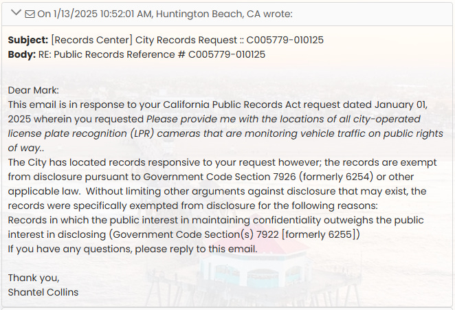
I confess that my goal in submitting the CPRA request was really to get the city on record as failing to be transparent about spying on the public, and I succeeded.
It was now GAME ON. My obsessive-compulsive tendencies are a superpower that allows me to lock in with intense focus and immerse myself in a flow state where time seems to slow and the path to the goal reveals itself.
Driving the City, Both Virtually and Physically
Google Street View is an amazing tool for exploring a city from the comforts of your home office. It’s so simple to plop your virtual self into the middle of any arterial intersection and take a quick 360 degree look around to see what’s mounted on traffic signals and nearby street lamps to see if any telltale solar panels are present that might be powering ALPRs.

For example, in the above Street View image of Brookhurst & PCH near the southeastern corner of the city, we see two solar panels and Flock ALPRs, one set attached to the foreground signal, and the other attached to the background street lamp.
You can find quite a lot of ALPRs this way by looking at intersections and selected business driveways. But ALPRs can also be attached to street lamps some distance away from signals, and it quickly becomes tedious to check every street lamp virtually.
There are also limitations to available Street View imagery, with some areas of the city being captured infrequently, and in some cases the most recently available image predates ALPR deployment.
So, to be complete, physically driving the city is necessary.
I’ve found that once you’ve seen your first ALPRs in person, they’ll start to jump out at you as you’re doing your normal errands around the city if you keep a small bit of mindshare looking for small solar panels on poles as you drive.
I’m thankful for Tesla FSD, which is very good at just safely driving straight in uniformly flowing traffic, freeing up some mindshare for me to take quick glances for ALPRs. But if you are driving manually, be safe about this by doing most of your looking when stopped at red lights.
I’ve already done a fair amount of physical driving on PCH, Main Street, Huntington Harbour, Bella Terra, and Pacific City, plus various selected areas along the city boundary. But I still need to comprehensively drive the arterial grid. If I do it an hour here and an hour there, it will take me a few more weeks to complete.

How You Can Help
My routine errands only cover a relatively small portion of the city, and realistically I’ll only be able to survey the full arterial grid once or twice a year. The city has plans to deploy MANY more ALPRs, roughly doubling what’s out there now, so widespread ongoing surveying will be required to keep tabs on the growing ALPR surveillance network as it steals more privacy.
If you want to help map the ALPR network, safely pay attention to the roadside during your daily driving. Small solar panels will most likely be powering a Flock ALPR, so look for solar panels and a camera on the same pole with a cable connecting them together. The city also uses smaller Motorola (formerly Vigilant) ALPRs mounted on the underside of signal arms above the traffic lanes, using power from the signal rather than solar.
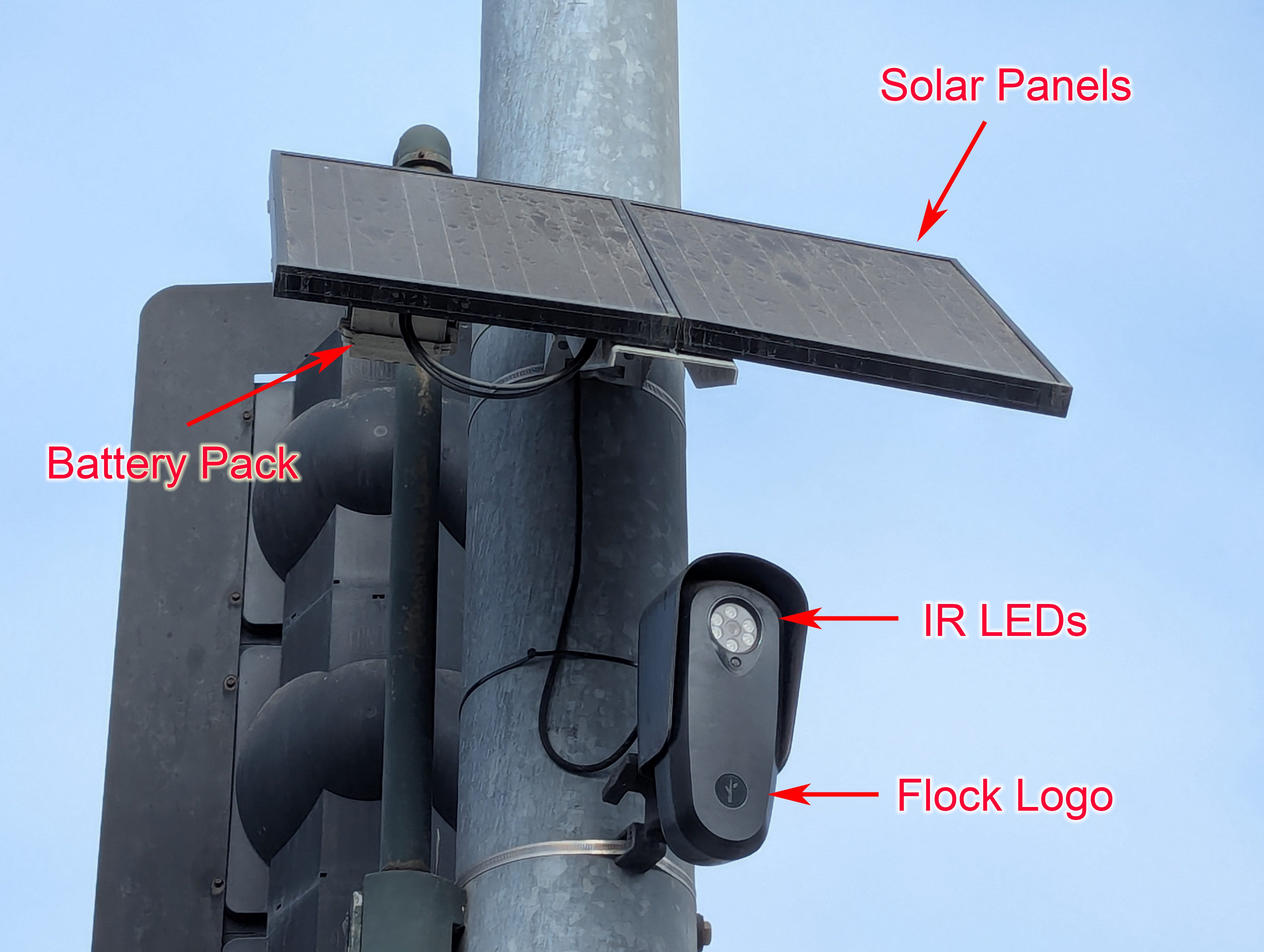
Flock ALPRs are the most common and appear to be the city’s preferred brand. The city recently negotiated a large contract for additional Flocks, so expect to see more of these in the future.
Note the presence of the six infrared LEDs surrounding the central lens. Seeing LEDs like that on any camera strongly suggest the camera is an ALPR capable of reading license plates in the dark.
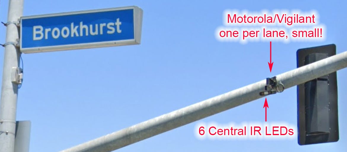
The city has also deployed three sets of three Motorola/Vigilant ALPRs, one per lane, on signal arms above traffic lanes at Adams Ave & Brookhurst St, Bolsa Chica St & Bolsa Ave, and Warner Ave at Newland St. I found a city hardware license renewal for nine Motorola/Vigilant ALPRs, so I believe I have found all of them that are currently active. Still, if you see anything similar to this mounted on the underside of signal arms, let me know.
Again, note the presence of the six infrared LEDs. Seeing LEDs like that on any camera strongly suggest the camera is an ALPR capable of reading license plates in the dark.
The Brightwater HOA has deployed a different brand of ALPR at each end of Brightwater Dr, but I don’t have a good photo to show you. However, those ALPRs like the others have the telltale infrared LEDs.

The city also operates a large network of traffic management cameras, which have been mounted high on signals at most intersections with significant traffic. Many different models are used, some fixed position, and others with pan-tilt-zoom (PTZ) capability as shown above.
While any camera of sufficient image quality *might* be capable of reading license plates, you can’t be sure in the absence of infrared LEDs.
I do not care about any camera without infrared LEDs.
I also do not care about cameras in gated communities like Seabridge Villas.
If you spot a camera in a public area that you think might be an ALPR, check the ALPR map. If the camera is NOT on the ALPR map, reach out to me with the precise location and a photo from cell phone, dashcam, or Street View, and I’ll be happy to add it to the map after verification. I’ll also add it to my personal ALPR spreadsheet in case anything ever happens to the crowd-sourced map and I need to rebuild it elsewhere.
Who watches the watchers? All of us should. Together we can push back against the surveillance state.
How to Protect Your Privacy
In a free country, law-abiding residents should be free to move about without being subject to government surveillance without any finding of probable cause of criminal activity. But this is not a truly free country, unfortunately, and ALPR technology is particularly insidious because it is collecting personally identifiable information about your location history that can be abused.
Still, knowledge is power, and if you know the fixed locations of ALPRs, you can protect your privacy by simply altering your driving route to avoid them.
The avoidance strategy was in fact recommended by the HBPD itself at the city council study session I attended a decade ago. The topic of discussion was deployment of the first three ALPRs at some of the entrances to Oak View as a crime prevention measure. Law-abiding residents thought it was unfair that their privacy was going to be violated. The HBPD officer on hand recommended that since only some of the neighborhood entrances were going to be monitored, residents concerned about their privacy could simply use the camera-free entrances instead.
So, the camera avoidance strategy I am suggesting here is no different than the advice HBPD once gave to Oak View residents.
Because of current gaps in the ALPR network, it’s still possible to drive to nearly any destination in the city without being tracked by the government. The exceptions that I am currently aware of are Trinidad Island, the Brightwater neighborhood, and the Summerlane neighborhood. Access is limited with one way in and out for Trinidad, two ways in and out for Brightwater, and two ways in and out for Summerlane, and each of those access points has ALPR cameras. There are likely other exceptions, so driver beware.
Note that no ALPR map will ever be complete or continuously updated, so there is always a risk that a vehicle registered to your household or business will have its license plate captured and entered into a surveillance database. Also note that mobile ALPRs are active in the city, some mounted on police patrol vehicles, and others used by parking enforcement contractors, none of which can be mapped. By the time you see a new ALPR camera, it has probably already seen you if you are in its field of view.
If you want to go to further lengths to protect your privacy from ALPRs, never travel in a vehicle registered to your household or business. Use ridesharing or public transit or even bikes or your own two feet to get around.
Some final words about privacy protection.
Every networked mobile device that you own such as cell phones, smart watches, fitness monitors, or even many cars pose a continuous privacy threat while powered on. For the highest level of privacy protection, leave these devices powered off when not in use.
Next Steps in My Investigation
I’ll be starting to drive the arterial grid soon to look for more ALPRs, and while I’m at it, I’ll also be wardriving to see whether additional insights can be gained from wireless networks detected from public rights of way. Upon returning from each drive, I’ll update the ALPR map with any new camera sightings.
I still need to put together a cohesive deployment timeline for the ALPR network with specific examples of how the city deliberately keep this surveillance system below the public’s radar. That will require spending quite a lot of time digging through city archives.
I’ll be back. ;-)
First, thank you for your research. I, too, am leery of the surveillance state that we’ve become.
You start your article by sharing your dislike of HB’s city council’s “unanimous adoption of Resolution No. 2025-01 “declaring the City to be a non-sanctuary city for illegal immigrants for the prevention of crime” and further how the resolution allows “…police to [use] “every means and resource necessary” to aid federal law enforcement agents in the deportation of hard-working immigrants who only seek to pursue the American Dream of opportunity.”
But then at the end, under ‘How to Protect Your Privacy’ you write, “In a free country, law-abiding residents should be free to move about without being subject to government surveillance without any finding of probable cause of criminal activity.”
Do you see the contradiction? The illegal, undocumented immigrants by way of coming here illegally, are NOT law-abiding. They broke the law in the manner that they came here. So, while most of these immigrants might be “hard-working,” if they came here illegally they are not law-abiding.